Sellaronda - El Clásico de las Dolomitas
Ruta: Puerto de Campolongo, Pordoi, Sella y Puerto de Gardena
Who is suited to ride the Sellaronda?
The Sellaronda by road bike is a demanding tour, aimed primarily at experienced cyclists. It is particularly suitable for people with a solid base of fitness and sufficient experience in mountain riding. The route includes several steep climbs and descents, so technical skills in handling a road bike are as important as endurance. The tour also requires thorough preparation, both in terms of physical conditioning and planning the route, as well as carrying essential equipment and provisions. Beginners or those without experience in similar altitudes and distances may find the tour too challenging.
Key points along the route
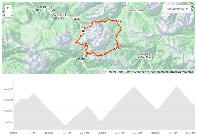
The Sellaronda road cycling route includes four major passes in the Dolomites: Passo Gardena, Passo Sella, Passo Pordoi, and Passo Campolongo. Each of these passes offers unique landscapes and challenges. Passo Gardena connects Val Gardena and Val Badia, while Passo Sella provides fascinating views of the Sella group. Passo Pordoi is renowned for its historical significance in cycling, and Passo Campolongo connects Corvara in Val Badia with Arabba. In total, the Sellaronda covers about 1,800 meters of elevation gain. The full route is approximately 60 kilometers long, making it a demanding but achievable challenge for well-trained cyclists.
What do you need for the tour?
A well-maintained bicycle is essential. The bike should have a reliable gear system to handle the climbs and descents of the Sellaronda. A lightweight, stable frame is recommended to save energy on long ascents and provide safety on the descents. In terms of safety gear, a helmet, gloves, and suitable cycling clothing that offers protection in various weather conditions are crucial. In the Dolomites, the weather can change quickly.
Cycling glasses to protect against insects and sunlight are also a must.
It is also advisable to bring a small bike repair kit, sufficient isotonic drinks, and food that is both energy-rich and easy to digest. A GPS device is not strictly necessary, as the passes are well signposted.
When is the best time of year to ride the Sellaronda?
The best time of year to ride the Sellaronda by road bike is generally from June to mid-September. During this period, the weather is most stable and temperatures are pleasant.
There is usually little or no snow on the passes during these months, and the days are long enough to provide plenty of daylight for the tour. However, mountain weather is unpredictable, so it is always wise to be prepared for sudden changes.
Important note: In high season, especially July and August, the pass roads and mountain villages can get quite busy due to tourism. Sports cars and motorcyclists share the roads with cyclists.
On June 6, 2026, and September 12, 2026, from 08:30 to 16:00, the passes around the Sella are reserved exclusively for cyclists (around 18,000 participants in 2024)!
Where is the best starting point for the Sellaronda, and in which direction should you ride?
A popular starting point for the Sellaronda by bike is Corvara in Val Badia or Selva di Val Gardena (German: Wolkenstein) in Val Gardena (German: Grödnertal).
As for the direction, there are two options: clockwise or counterclockwise.
We recommend riding counterclockwise, starting in Selva di Val Gardena, heading towards Passo Sella, then Passo Pordoi, continuing to Passo Campolongo to Corvara, and finally up to Passo Gardena with the descent back to the starting point in Selva di Val Gardena.
Both directions offer spectacular views and unique challenges, so the choice often depends on personal preference and fitness level.
- Passo Sella (2,240 m)
- Passo Pordoi (2,239 m)
- Passo Campolongo (1,875 m)
- Passo Gardena (2,121 m)
Route: Where does the itinerary run?
The route circles the Sella massif in the Dolomites. The main peaks of the Sella group are Piz Boè (3,152 meters), the highest point of the massif, as well as other prominent summits like Sass Pordoi, Piz Gralba, and the Sella Tower.
Passo Sella marks the entrance to the Fassa Valley. After crossing Passo Sella, the route continues to Passo Pordoi, which leads into the Arabba Valley. From Passo Pordoi, you descend to Arabba and then climb again to Passo Campolongo, which leads into Val Badia. In Val Badia, you ride through Corvara and La Villa (Stern), before the final climb to Passo Gardena. After Passo Gardena, the route descends back to Selva di Val Gardena, where the loop closes, and you can continue to Santa Cristina or Ortisei. This route offers an impressive variety of landscapes, from alpine meadows to rocky mountain peaks, and passes through some of the most beautiful valleys and villages of the Dolomites.
Why is the Sellaronda a special cycling tour?
The route is a unique combination of challenging climbs and breathtaking scenery.
The passes are not only famous for their beauty but also for their significance in cycling history, especially the Giro d’Italia.
Moreover, the Sellaronda passes through three linguistic regions of Italy: German, Italian, and Ladin; giving riders a culturally diverse experience.
Navigation: How do you find your way on the Sellaronda?
The Sellaronda road cycling route is excellently signposted, making navigation easy. At each of the four passes and at key intersections, there are clear signposts. These signs not only provide directions but often information about the distance to the next pass or other main points. Thanks to this clear and informative signage, cyclists can find their way without special maps or GPS devices. However, it is always recommended to carry a map or a smartphone with a navigation app / Google Maps, in case you want to leave the main route or need extra information.
How long does it take to complete the route by road bike?
The time needed to complete the Sellaronda road cycling route depends greatly on individual fitness, experience, and the rider’s pace. On average, well-trained cyclists need about 4 to 6 hours to cover the entire 60-kilometer route with roughly 1,800 meters of elevation gain. Less experienced or less fit cyclists should plan for more time, possibly 6 to 8 hours or longer. It’s important to note that the Sellaronda is a challenging route and riding time can be affected by factors such as weather conditions, traffic, and personal fitness. A well-planned tour with sufficient breaks and a sensible pace is essential for a safe and enjoyable cycling experience.
Preguntas Frecuentes sobre la Sellaronda en Bicicleta de Carretera
¿Cuál es la longitud de la Sellaronda y qué desnivel hay que superar?
La Sellaronda cubre aproximadamente 53 kilómetros con un desnivel total de unos 1.700 metros.
¿Qué puertos se cruzan en la Sellaronda?
En la Sellaronda, se cruzan cuatro puertos de las Dolomitas: el Puerto de Sella, el Puerto de Pordoi, el Puerto de Campolongo y el Puerto de Gardena.
¿En qué dirección se recomienda hacer la Sellaronda?
La Sellaronda se puede hacer tanto en sentido horario como antihorario. Recomendamos hacer la ruta en sentido antihorario.
¿Cuáles son las condiciones de la carretera y la situación del tráfico en la Sellaronda?
Las carreteras de los puertos están generalmente bien mantenidas, sin embargo durante la temporada alta (julio, agosto) puede haber más tráfico, especialmente motos y coches.
¿Qué temporada es la mejor para una vuelta a la Sellaronda?
La mejor época para una ruta en bicicleta de carretera en la Sellaronda es de junio a septiembre, cuando las carreteras están libres de nieve y las condiciones meteorológicas son mejores. Antes de una vuelta, debe consultar el pronóstico del tiempo y las webcams.
Sellaronda en Bicicleta de Carretera - Mapa con Track GPX
Sellaronda Bike Day 2026
El 6 de junio y 12 de septiembre de 2026, de 08:30 a 16:00, los cuatro puertos de las Dolomitas (Sella, Gardena, Pordoi y Campolongo) están reservados exclusivamente para ciclistas.
Debido al alto número de participantes, el comité organizador recomienda recorrer la Sellaronda en sentido contrario a las agujas del reloj para evitar colisiones en las carreteras de los puertos. Los participantes pueden comenzar desde Corvara, Colfosco, Arabba, Selva di Val Gardena, Ortisei y Santa Cristina.
Longitud: 63 km, Desnivel: 1780 m
Sellaronda en Mountain Bike
La Ruta Sellaronda MTB es un espectacular desafío de mountain bike que difiere significativamente de la conocida ruta de bicicleta de carretera en las Dolomitas. Esta ruta, que se puede hacer tanto en sentido horario como antihorario, ofrece una experiencia única para ciclistas de montaña con sus 58 km o 55 km y varios perfiles de elevación. Es importante enfatizar que esta ruta está diseñada específicamente para bicicletas de montaña y difiere fundamentalmente en su carácter y requisitos de la ruta de bicicleta de carretera.
Se requiere buena condición física y experiencia en mountain bike para completar la ruta. La ruta se puede abordar tanto con bicicletas de montaña tradicionales como con e-bikes. Para una experiencia y seguridad óptimas, se recomienda ir acompañado de un guía experimentado, especialmente si no está familiarizado con la región o la ruta. Toda la información necesaria, billetes de teleférico y detalles de la ruta están disponibles en el sitio web oficial sellaronda-mtb.com.
Rutas similares que podrían interesarte:
Eisjöchl
Vacaciones en el Tirol del Sur
Nuestras 4 recomendaciones para sus vacaciones en la región